Formation of Sima de las Palomas
SIMA DE LAS PALOMAS is a system of natural shafts and passages which presents karst features that demonstrate erosive effects of both endokarst (phreatic) and ectokarst (vadose) dissolution of the marble rock. The system probably began life by vertical dissolution producing a hole at the intersection of two faults (one running N65ºE, the other almost W-E). It became enlarged progressively by karst erosive processes owing to water flowing down into it from the steep hillside above, whether from rainstorms or even long-vanished springs. Water also deposited sediment inside the cave system. Calcium carbonate dissolved in water entering the cave was precipitated in some places as calcretions (e.g. stalactites, flowstone, etc.) or cemented sediment that had been deposited in others into conglomerates. Enlargement and development of shafts and passages seems to have been enhanced by presence of veins of micaschists, the dip of which tends inwards into the mountain and away from its slopes. This effect is seen well at the only cave on the hillside that still contains water which is called the Cueva del Agua (Water Cave), almost 1 km N of Sima de las Palomas. Today Sima de las Palomas does not contain any water though it is likely that as late as the nineteenth century water was present at the bottom of the Sima de las Palomas cave system.
Cortesy of Dr. Tomás Rodríguez Estrella, Cartagena Polytechnic University
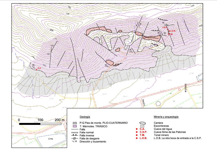
Geological map between Sima de las Palomas and Cueva del Agua
(courtesy of Dr. Tomás Rodríguez-Estrella, Cartagena Polytechnic University)
Some relevant features on the map are:
1. Marble with tremolite, in decimetre-thick beds dipping 30º-65ºN, exposed above poorly-developed piedmont accumulations.
2. There is a series of faults tending between N110E and N165E, some of which are dextral; Sima de las Palomas lies on a fault tending N160E.
3. There is a group of sinestral shear faults N-S tending between N20-2E, and at Sima de las Palomas a N-S fault is visible both in the mine tunnel and inside the cave.
4. There are normal faults that tend almost W-E; iron mineral is associated with them.
5. An inverse fault tending N110E crosses the footpath just before it reaches Sima de las Palomas, which has a warped surface; iron mineral is associated with it.
Translation of terms in the key:
Geología = Geology
P-Q pies de monte PLIO-CUATERNARIO = P-Q piedmont accumulations PLIOCENE-QUATERNARY
T. Mármoles TRIÁSICO = T. marbles TRIASSIC
Falla = fault
Falla normal = normal fault
Falla inversa = inverse fault
Falal de desgarre = shear fault
Dirección y buzamiento = direction and dip
Minería y Arqueología = Mining and Archaeology
Cantera = quarry
Escombreras = mine rubble
C.S.P. Cueva Sima de las Palomas = C.S.P. Sima de las Palomas cave system
Túnel minero = mine tunnel
L.O.B. La otra boca de entrada a la C.S.P. = L.O.B. The other shaft (“the miners’ shaft”) into the main chamber of the Sima de las Palomas cave system
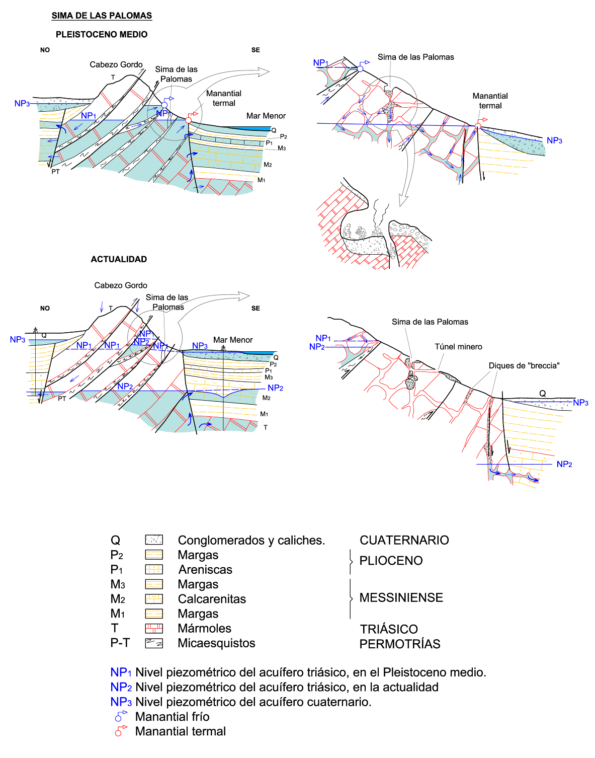
Translation of terms in the key
NO = NW, SE = SE
manantial termal = hot spring
manantial frío = cold spring
túnel minero = mine tunnel at Sima de las Palomas
diques de brecha = brecha dykes
Cuaternario = Quaternary (i.e. Pleistocene and Holocene)
Pleistoceno Medio = Middle Pleistocene
Actualidad = Nowadays
Plioceno = Pliocene
Messiniense = “Messinian” phase of the Upper Miocene
Triásico = Triassic
Permotrías = Permo-Trias
Q conglomerados y caliches = Quaternary conglomerates and calcretes
P2 margas = Pliocene marls
P1 areniscas = Pliocene sandstones
M3 marls = Upper Miocene (“Messinian” phase) marls
M2 calcarenitas = Upper Miocene (“Messinian” phase) calcarenites
M1 marls = Upper Miocene (“Messinian” phase) marls
T mármoles = Triassic marbles
P-T micaesquistos = Permo-Triassic micaschists
NP1 = likely Middle Pleistocene piezometric level of the Triassic aquifer
NP2= modern piezometric level of the Triassic aquifer
NP3 = piezometric level of the Quaternary aquifer
![]() = cold spring
= cold spring
![]() = hot spring
= hot spring